Gunung Rinjani - Part 1
Prelude
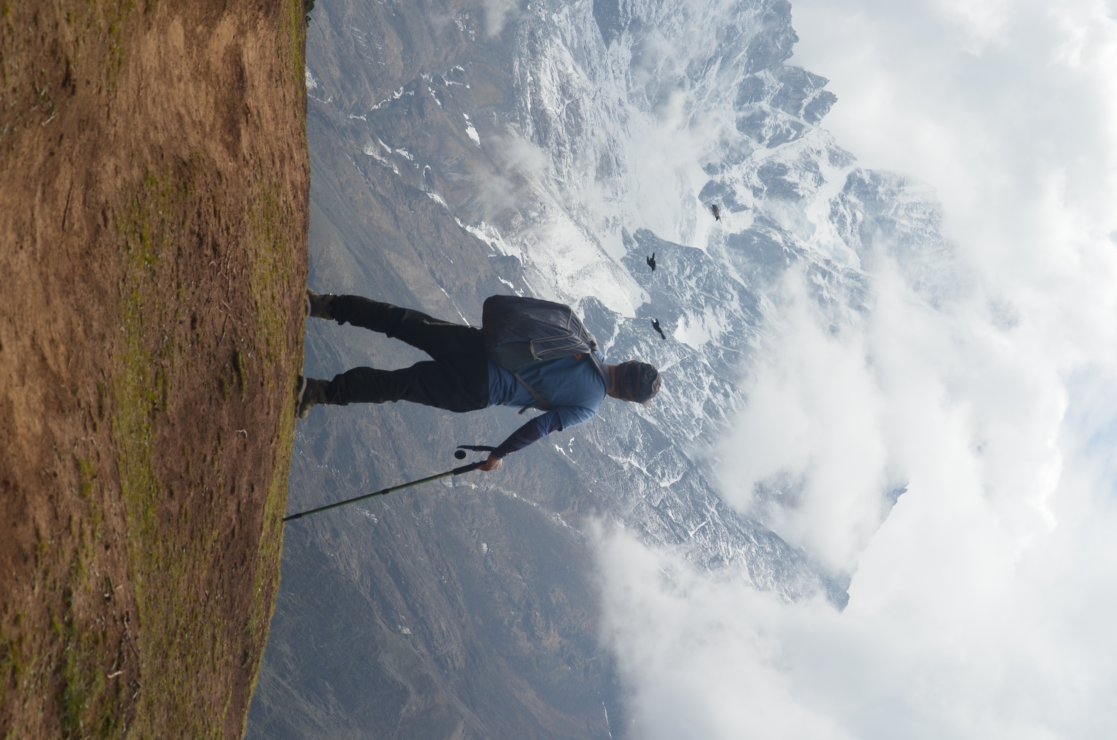
A few years back I trekked to the Mt Everest base camp and after that I was happy and content with my life that I had reached the pinnacle of adventure that a non-professional trekker of my caliber can reach. A couple of years after that, a mate of mine who had hiked the base camp along with me, posted a picture of him on a summit in his Instagram timeline with the caption “Mt Everest Base camp was really a cake walk compared to Mt Rinjani”.
This picture of him triggered my ego, there was fire in my belly and a sudden gloom and a dark realization that all my claims of glory and pride of me having achieved the unachievable by other mortal souls were all in vain. Now, there was an insatiable desire to conquer Mt Rinjani. This was how it all began!
Reaching Rinjani base is quite an adventure in itself. One has to take a flight to Bali, a private or shared taxi ride of 3 hrs to a harbour called Padang Bai, from where you have to take another ferry or a speed boat for about 3 hrs to Lombok. From Lombok harbour, you have to take another taxi, a drive of about 2 hrs to Sembulan or Senaru village which are the starting points from the trek.
There are several trails to reach the Rinjani summit. Trails starting from villages Senaru, Torean and Sembulan. Each trail is beautiful in its own way and has its distinct landscape. The trek in each of these trails starts with lush green tropical rainforests leading to savannah-like open grasslands and then steep slopes with pine and fern trees and large boulders which eventually leads to a stunning volcanic crater surrounded by a volcanic lake.
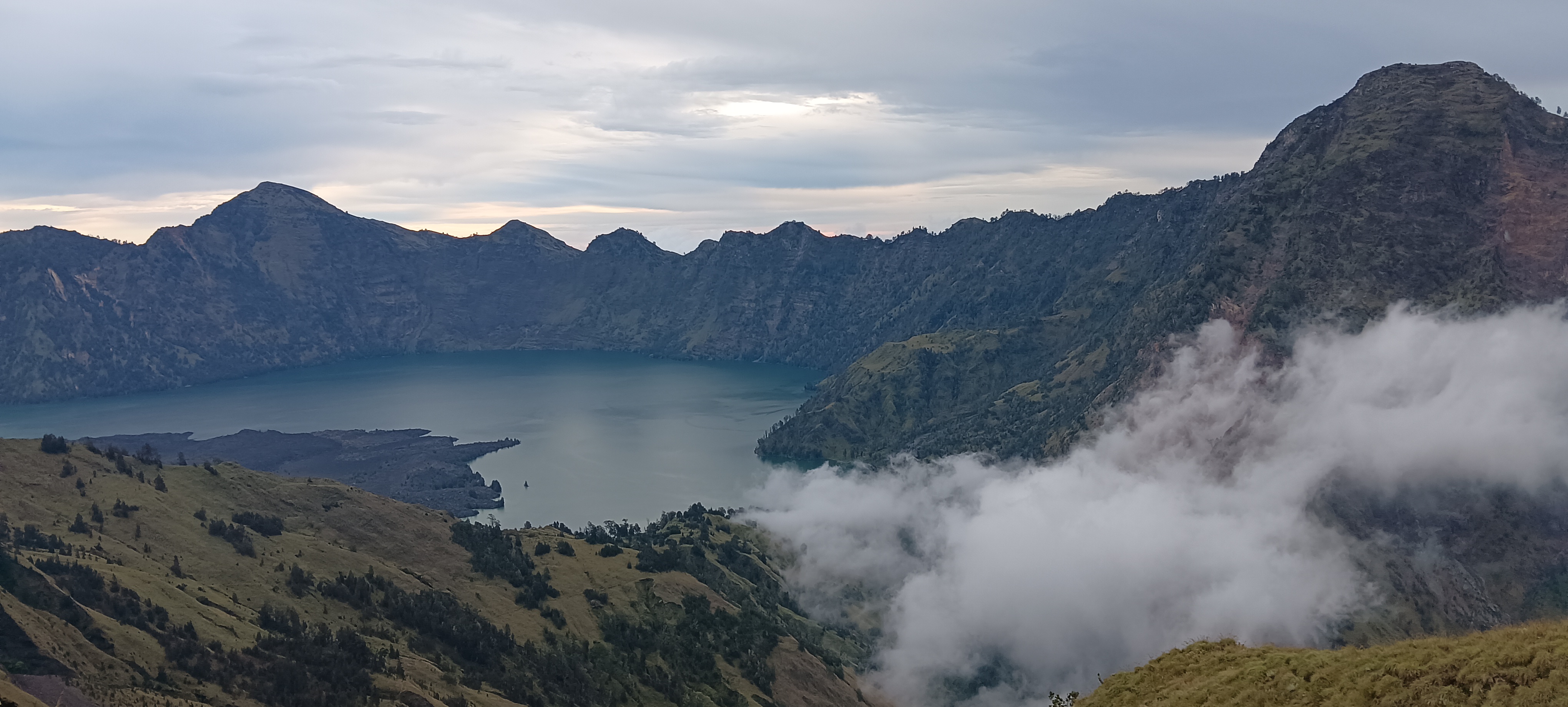
Rinjani is an active volcano in Indonesia. It is the 2nd highest volcano. It also has one of the most beautiful and stunning landscapes and it is one of the most stunning geological formations on earth. It is a perfectly cone-shaped mountain, just imagine the cone cut into half, the perimeter along the top is the Cauldron or Caldera, i.e. , a large hollow formed after the lava from a large volcanic eruption flushes out or eventually cools down over a period of time. Deep within the cauldron is a stunningly beautiful lake, called Sagera Anek ( translated from Indonesian as “Daughter of the Sea”). It’s vividly crescent shaped with uneven edges and it contains azure blue water. (It’s interesting to note here that how several sanskrit words have been imbibed into Indonesian vocabulary)
One cannot trek Rinjani by themselves. They have to go through a licensed trekking company. I booked with a local trekking team called Rinjani Backpackers. Each group typically consists of 10 trekkers, 2 guides and 5 porters to carry the tents, food and other equipment. The porters are the real heroes of Rinjani. They hike the mountain with just the slippers and some barefoot, and they carry a load of anywhere between 40 - 50 kgs, in two baskets tied to either ends of a long wooden pole, which they carry on their shoulder.
The trek to Rinjani summit can be completed anywhere between 2 to 5 days depending on your strength, physical and mental endurance levels, and the amount of time you wish to spend amidst the beautiful nature depending on the time you have at your disposal and also depending on the trail you choose to trek. I chose the 3 - day itinerary. 3 days for Rinjani is extremely strenuous and requires one to be in a considerably good physical fitness level. If you are able to run 5 kms in or under 30 minutes, consider yourself physically fit to hike Rinjani in about 3 or 4 days.
Day 1: Climb to the base camp
We start from our hotel/accomodation early in the morning. The guide gives a brief about the route and the itinerary on the previous day. There is also a medical check-up done to make sure your vitals are under acceptable threshold to complete the trek. They check your oxygen level and Blood pressure. My BP was a little higher than normal but my blood oxygen level was Alas!, 99% given that I was already at a considerably higher altitude. I remember one dude in my Everest base Camp trek saying that my blood oxygen levels were good enough to even climb Mt Everest!
My group consisted of two french girls, one french guy, a singaporean, one chinese girl and a chinese guy and two south koreans and myself a lone indian. This trek mostly consists of white dominated troupes. Hence, sometimes I had to spare the embarrassment of a few folks thinking that I was one of the porters or the guide. Only when they saw the expensive shoes, accessories and the DSLR camera hanging around my neck would they realize that I was one of the trekkers!
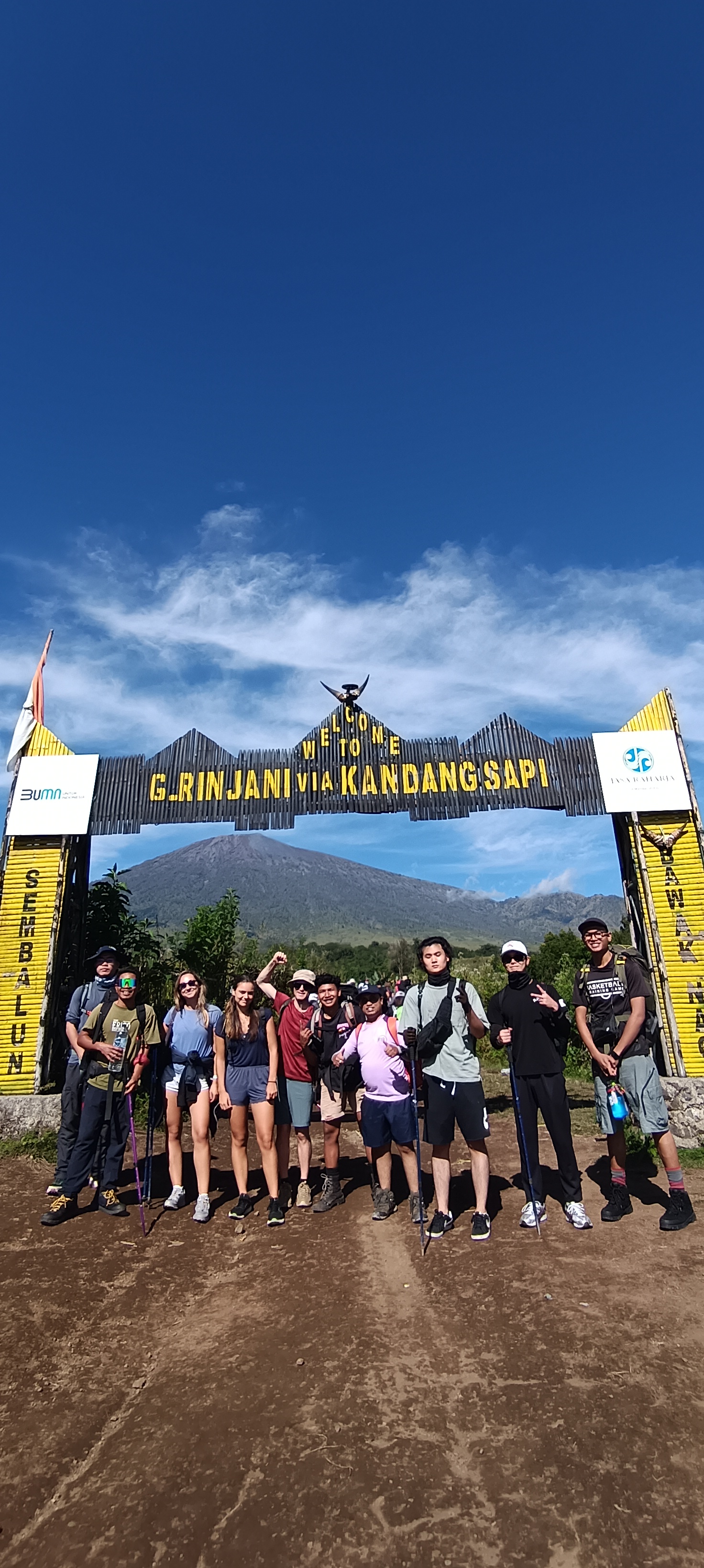
Post health check, we were whisked off on the back of an open goods truck to the starting point of the trek. Here we had to register ourselves and take an undertaking: “If we die or break our bones under any circumstances during the trek, none of the folks out there organizing the trek or involved in it directly or indirectly, are responsible for that. It’s entirely on our own will and wish”. This gave me my first round of jitters, one among many that I would encounter on the way up to the base camp. The hike started at a point called Kandangsapi. We took a group photo here in front of a small arch with the majestic Rinjani in the background and the trek was kick-started officially with a jovial note. The initial few kilometers of the trek is like an off-roading path and we could see some off-roading enthusiasts whipping past us. There are 4 resting areas that you encounter on the first day of the trek, called Pos 1, 2, 3 and 4. We pass through lush green rain-forests during the first hour or so, then Savannah like grassland over the slopes for the next couple of hours which then subsequently leads to steeper climbs with sparsely spread coniferous trees. We had a hearty meal at Pos 3, consisting of sticky rice, eggs , fried vegetables and fruits. After Pos 3, the climb got steeper and more strenuous and this is where I had my next jolt. The path here onwards gradually started to gain more volcanic mountain character. Loose soil and gravel, every step needing more per unit effort than the previous stretches. A lady, who I presumed was older than me, saw my plight, struggling to climb up and very kindly enquired me if I was alright and needed a helping hand. It was a shame and once for all put to rest all my delusions about my fitness level. I had a lot of questions about my fitness. While pondering thus, I saw around 4 porters climbing down carrying a hammock tied to a long wooden pole, in what seemed to be a human lying seemingly unconscious. When I enquired fellow climbers around me, they told me that the fellow had supposedly slipped and fallen and broken his bones and become immobile and hence he was being carried down (Later, in the camp I found out from my fellow climber from Singapore that the person being carried down was actually dead! This sent shivers down my spine). After a couple of more hours of plodding through the steep mountain side and a total vertical climb of almost 1500 mts, I finally reached the volcano crater rim. This was our base camp for day 1. I guess this narrow flat ridge is wrongly called the volcano crater, whereas the actual volcano itself is a smaller mountain within the larger one. We can call this as the edge of the Cauldron, the hollow remains of the mountain after all the hot lava and magma have flushed out and cooled down over a longer period of time. The chinese girl who was quite agile reached much later after me. We had a wholesome supper of rice, egg, fried vegetables, fruits and a hot cup of tea. We slept early as the main drama was all happening the next day! But I didn't get any sleep. All through I was thinking about the dead person being carried down in the hammock and a lingering fear if I would be able to make it to the summit or not, what if I'm stuck in between, incapacitated to neither climb up, nor come down.
Day 2: Summit Push
This was D-day! I woke up at 1.30 AM. We were served with a helping of toast and hot tea. I usually do not take a step out of my den without having performed my morning ablutions. Hence I had to quickly find a silent and secluded spot to unburden myself. Once done, I was a soldier ready to face 100 warriors. In a matter of minutes, I sported all my gear and was ready to march. Our guide to the summit was one of the porters who had doubled up as a guide. My friend from France, very generously offered me his lone hiking stick. I was elated! Only to realize later that it was actually broken, the pipes of the stick wouldn't lock-in and the moment you pressed it hard onto the ground, the inner pipes would unlock and snap-in and disappear. Thus, the stick became an added burden to me instead of helping me in my climb. The climb from base camp to the summit can be divided into 3 segments: A steep climb of around 500 mts on a path covered with sand, ash and gravel. Every step buries your feet deep into the sand and you take it out with great effort. The path is zig-zag and you barely know what lies on either side of the path. After a 2 to 2.5 hours of climb you can breathe a sigh of relief. You reach a flat ground. The next stretch is a relatively easier, almost flat and slow ascent of around 100 to 200 mts. This part is a cake walk compared to what lies ahead for you. You get a window of around 30 - 40 minutes to take a breath and cover these roughly 200 mts of climb comfortably. The third stretch is the final push to the summit. This is the most dreadful, dangerous and frightening part of the climb, where you are exposed to all the elements, where taking every step feels like climbing yet another mountain altogether. You are climbing along a very narrow ridge with a steep fall of anywhere between 1000 to 1500 mts on either side. This stretch continues all the way up to the summit of the mountain. The third stretch itself can be divided into 2 sections. These two sections combined form the shape of a W (UU) , with smooth curves. You can imagine your buttocks. The middle part, where the 2 U’s intersect, is the most deadly part of the climb. The path further narrows down here to just a few feet of width. It is like a bridge connecting the two sections. Only one person can cross this narrow stretch at any given time. There is a steep fall of over 1000 mts on either side. Winds blowing at over 100 kms/hr speed continuously batter you. The ash dust brushing past your eyes and face is an icing on the cake. Add to it the sub-zero freezing temperatures. Humans are not designed for survival here. God forbid you don’t fall into the bowels of the volcano or out of the mountain on either side of this narrow stretch. This is what you can define as hell. Once you make through this, your hassles are not over as yet. You’ve still got over 400 - 500 mts to climb yet. This is the second U of the UU. Every step is equal to climbing a mountain and crossing a valley. Your body is constantly persuading you to stop here and return back. But your heart and mind doesn’t want to give up. You sit down for every step you take, take a deep breath, grudgingly lift up your body to take the next one. Wind and ash are constantly battering your face. The moment the wind picks up speed, you stay put on your path, lest you fall into the deep gorge on either side into oblivion. At the final stages of the climb, you're literally down on your knees, crawling up rather than climbing, dragging yourself and your hiking sticks up. You’re breathing heavily and staring upwards and praying to the almighty to bring an end to this peril.
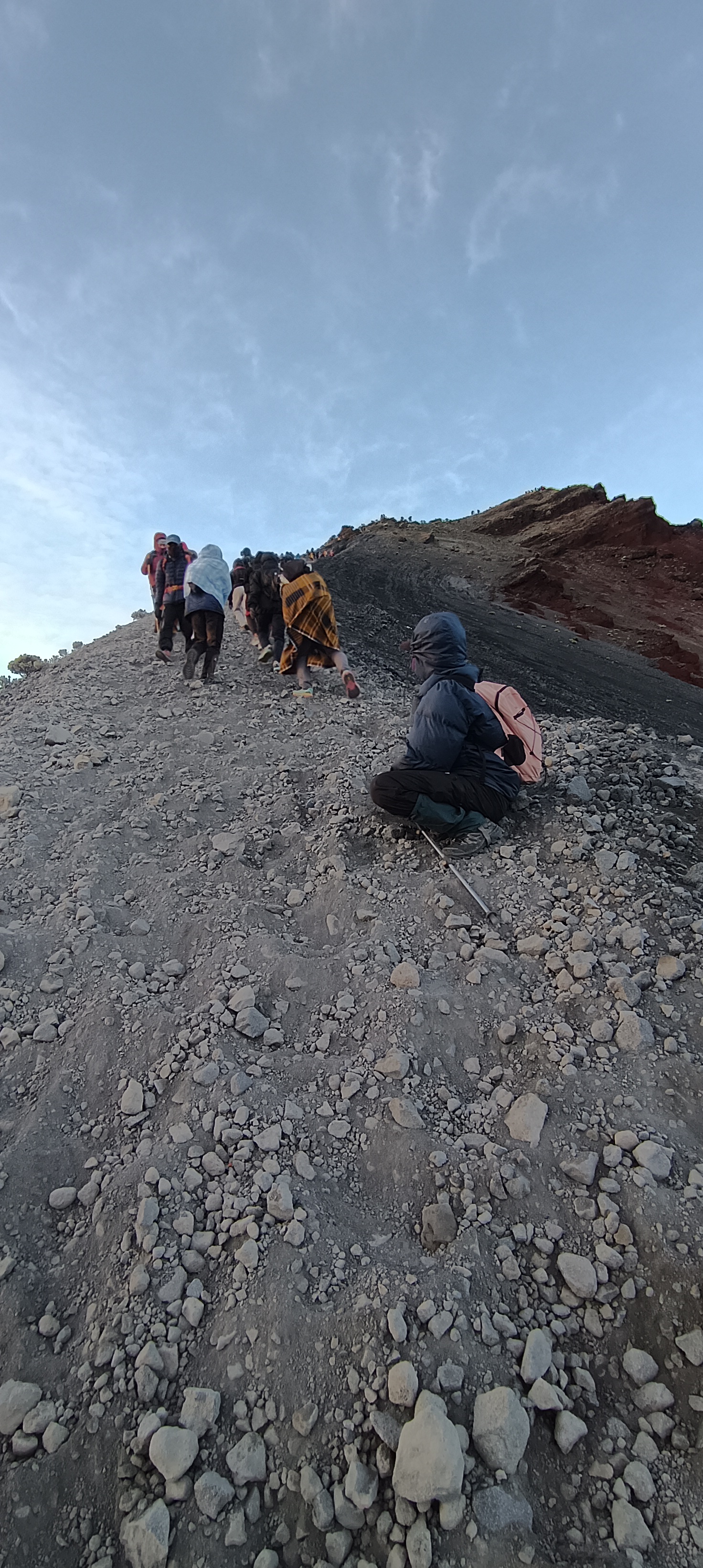
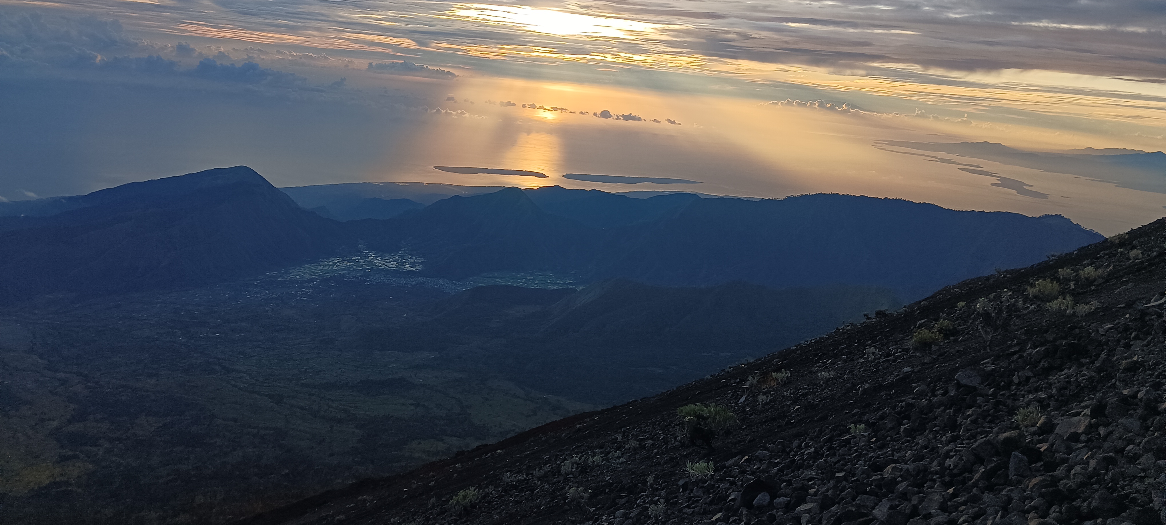
Then suddenly, after an eternity, in the midst of haze and fog you see that all headlamps and torches which until now were constantly moving ahead like a trail of ants have now come to a standstill at a distance. Now they are constantly buzzing around the same place like a swarm of mosquitoes. That is the SUMMIT! Your heart skips a beat! You are almost there. You are burst with energy, but your body still does not permit you to skip, jump or hop. You drag yourself up the last few meters brimming with confidence. The first rays of sun start peeping out of the horizon and now you’re able to faintly discern the peak and it starts seeping into you. The view is surreal! There is a streak of red all around you along the horizon which is in fact below you. You see a yellow mould rising out of the horizon just as you step into the gateway of the summit. Everything is bright now! (This is the end of narration in third person)
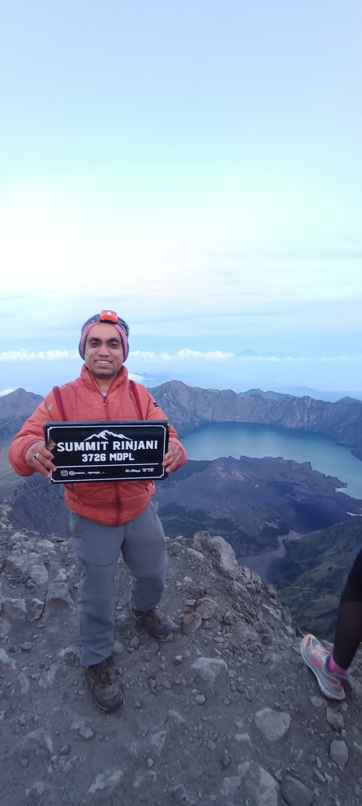
I was now at the summit of one of the toughest peaks to climb! I made it, after years of deliberation! I had conquered the Rinjani! I took a moment to soak in the success. My hands were freezing if I took off the gloves, but I had to since there was no way I was going back without clicking photos and videos of my conquest! After the mandatory photoshoot, a multitude of photos and the one compulsory photo holding the board with the words “Gunug Rinjaji, 3726 Mts”!
© www.kiranbalakrishna.in. All Rights Reserved. Designed by Kiran Balakrishna